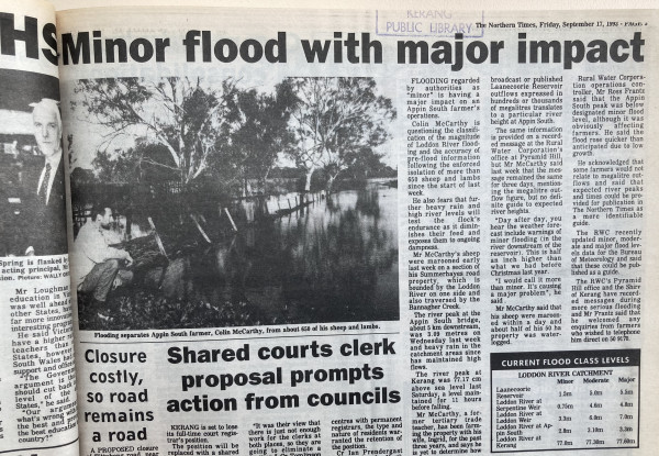
FLOODING regarded by authorities as “minor” is having a major impact on an Appin South farmer’s operations.
Colin McCarthy is questioning the classification of the magnitude of Loddon River flooding and the accuracy of pre-flood information following the enforced isolation of more than 650 sheep and lambs since the start of last week.
He also fears that further heavy rain and high river levels will test the flock’s endurance as it diminishes their feed and exposes them to ongoing dampness.
Mr McCarthy’s sheep were marooned early last week on a section of his Summerhayes road propery, which is bounded by the Loddon River on one side and also traversed by the Bannagher Creek.
The river peak at Kerang was 77.16 cm above sea level last Saturday, a level maintained for 11 hours before falling.
Mr McCarthy, a former tertiary trade teacher, has been farming the property with his wife, Ingrid, for the past three years, and says he is yet to determine how broadcast or published Laanecoorie Reservoir outflows expressed in hundreds or thousands of megalitres translates to a particular river height at Appin South.
The same information provided on a recorded message at the Rural Water Corporation’s office at Pyramid Hill, but Mr McCarthy said last week that the message remained the same for three days, mentioning the megalitre outflow figure, but no definite guide to expected river heights.
“Day after day, you hear the weather forecast include warnings of minor flooding (in the river downstream of the reservoir). This is half an inch higher than what we had before last Christmas year.
“I would call it more than minor. It’s causing a major problem”, he said.
Mr McCarthy said that his sheep were marooned within a day and about half of his 50 ha property was waterlogged.
Rural Water Corporation operations controller, Mr Ross Frantz said that the Appin South peak was below designated minor flood level, although it was obviously affecting farmers. He said the flood rose quicker than anticipated due to low growth.
He acknowledged that some farmers would not relate to megalitre outflows and said that expected river peaks and times could be provided for publication in The Northern Times as a more identifiable guide.
The RWC recently updated minor, moderate and major flood levels data for the Bureau of Meteorology and said that these could be published as a guide.
The RWC’s Pyramid Hill office and the Shire of Kerang have recorded messages during more serious flooding and Mr Frantz said that he welcomed any enquiries from farmers who wished to telephone him direct on 50 9170.
CURRENT FLOOD CLASS LEVELS
LODDON RIVER CATCHMENT
| Minor | Moderate | Major | |
| Laanecoorie Reservoir | 1.5m | 5.0m | 5.5m |
| Loddon River at Serpentine Weir | 0.75m | 4.6m | 4.8m |
| Loddon River at Loddon Weir | 3.3m | 6.0m | 7.0m |
| Loddon River at Appin South | 2.8m | 3.10m | 3.3m |
| Loddon River at Kerang | 77.0m | 77.30m | 77.60m |