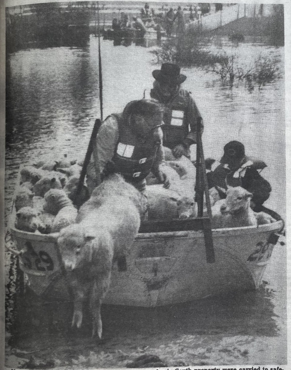
THE district is bracing itself for major flooding of the Loddon River and its tributaries.
Flood levels are expected to be similar to the record floods which devastated much of the district in August 1981.
The Loddon River is expected to peak at Appin on Saturday and at Kerang on Monday, with major flooding predicted.
The expected major flood levels follow a recent minor flood and will take some time to recede due to the high volumes of water.
With the Loddon River downstream of Laanecoorie Reservoir, east of Dunolly, peaking at 5.82m on Monday, Rural Water Corporation controller of operations at Kerang, Mr Ross Frantz believes this year’s flood will at least reach 1980 levels when farming and road damage losses exceed $20 million.
Three recorded flood heights of 5.67m, 5.35m and 5.02m were measured at Laanecoorie that year.
The Loddon River at Kerang reached a record 77.845m (Australian Height Datum above sea level) in 1981 and a flooded to 77.31m last year. Previous highs of 77.78m and 77.63m were recorded in 1975 and 1983 respectively.
Mr Frantz believes the river will reach between 77.6m and 77.8m at Kerang next week.
The flood peaked at 3.09m at Appin in 1981 and 3.14 m last year and is expected to rise to between 3.1m and 3.3m this weekend.
The Avoca River is expected to rise at Quambatook on Friday and exceed the flood level on Saturday, peaking on Sunday and creating moderate flooding with levels between 2.2 and 2.3m
Moderate flooding of the Murray River is expected upstream and downstream of Barham, with a peak of between 6m and 6.1m
The RWC is draining Kangaroo and Racecourse Lakes to create space for the flood waters and the Washpen regulator will be in full operation at the peak of the flood at Kerang.
It is also trying to create added capacity at Kow Swamp.
Mr Frantz said the RWC would try to outflow excess Avoca River water down the 6/7 Channel to the Little Murray Weir.
Emergency service personnel, municipal officials, RWC and representatives of other relevant Government departments met on Tuesday and again yesterday and have taken measures to try to cope with the floods under the local provisions of the State Disaster Plan (Displan).
Major Flood Levels
Loddon River peaks similar to record 1981 flooding are expected in the district from this weekend:
– Appin South 3.15m-3.25m (3.09m 1981).
– Kerang 77.6m-77.8m (77.84m 1981).
Flood wardens located around the district have been warned and will advise their neighbors of the impending floods.
Sand and sandbags will be available through the shire and people are encouraged to make use of these early.
Both councils are checking major flood levees and the shire is establishing some banks along roadways.
District Displan co-ordinator, Chief Inspector Henry Button said the committee needed to prepare for the worst and look at stock transfer, evacuation if necessary and flood relief measures.
Shire engineer Mr Peter McDonald said the flood would probably cause road closures and broken banks, however full-scale evacuations were unlikely.
Borough engineer, Mr Colin Campbell said no real problems were anticipated in the borough due to protection by the one-in-100-year flood levee, with the exception of the northern boundary which was some cause for concern.
Mr Campbell said based on the projected flood level, the borough was doing works it thought necessary prior to the floods.
Some road closures are expected around Quambatook for short periods and there could be some problems between Kerang and Lalbert.
Mr McDonald Said all Major arterial Roads were expected to be accessible.
The Pyramid Creek, which flows into the Loddon River at Kerang Weird, is not expected to reach 1981 levels, however weather and river flows will determine its level. Significant flows have been recorded on the Bullock Creek, which is rising.
The Loddon River downstreem of Laanecoorie yesterday morning measured 2.48m and was falling. It was 6.55m and falling slowing at Loddon Weir at Fernihurst.
The river was steady at 8.97m at Appin and was expected to rise quickly yesterday afternoon. at Kerang it measured 76.74m and was expected to rise late today.
The Avoca River was 5.93m and falling at Charton measuring 1.56m and steady at Quambatook, where it was expected to peak at 94.47 yesterday morning.
Flooding Information
The Shire of Kerang offices in Victoria will be the Displan headquarters for co-ordinating flood protection efforts.
Details about flood levels and expected peaks are available 24 hours per day by rinign a recorded flood warning message on 52 2307.