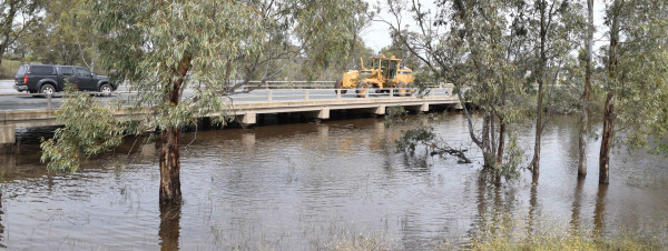

FLOODING in the Loddon River is predicted to peak around the moderate flood level at Kerang this weekend.
Higher than usual flows continue to make their way downstream following above-average September rainfall and heavy falls south of the region earlier this month.
The Loddon River peaked at Appin South on Wednesday above the major flood level of 3.3 metres – 17 centimetres higher than the highest level recorded during last month’s flood event – and is falling slowly.
It is predicted the river will remain above the moderate flood level of 3.1 metres today.
As of yesterday, the Loddon River at Kerang was 77.05 metres above sea level and rising, with a predicted peak around the moderate flood level of 77.5 metres above sea level during the weekend – 54 centimetres higher than last month’s peak.
Residents downstream of Kerang are also preparing for the rising waters, with the river height predicted to increase at Benjeroop between today and tomorrow.
Flood wardens have spent time checking local levee networks to see how the barriers have held up since last month’s flows, but are confident the situation will not be as bad as first predicted.
“Unless we get another significant rain event in the southern catchment of the Loddon River, we will be off the hook,” John Baulch, flood warden at Bowden’s Bridge, upstream of Benjeroop, said.
“However, as I have said to some of the locals here, history shows that if we have a wet September, usually we will have a wet October.”
Meanwhile, the Avoca River at Quambatook is now below the minor flood level, and will continue to fall below yesterday’s height of 1.93 metres as flows head downstream to the marshes, located within the Koorangie Game Reserve, and Lake Bael Bael.
“The water has well and truly reached the marshes, and Lake Bael Bael is looking glorious,” Quambatook Stores manager, Chelle Espagne said.
“Farmers are still monitoring levee banks, but there have been a couple of breaks that have impacted some crops.
“We’re just lapping up having a full river again. Now all we have got to do is be like Brim and work out a way to keep the water in the town.”
Monitoring will also continue along the Murray River, with a moderate flood warning in place from the Goulburn River junction to the Wakool River junction.
It is predicted the river will reach the major flood level of 7.8 metres at Torrumbarry Weir on Monday with the river to reach 6.1 metres at Barham next Thursday with moderate flooding to occur.
Residents are reminded to never walk, ride or drive through floodwater, and to not allow children to play in floodwater.
The State Emergency Service’s flood emergency response number is 132 500.